 Growth Management Law Change
Public Parcel Viewer
The Public Parcel Viewer maps for Washington County towns provide information for each town on tax map parcels and assessment information. Please note these are on-line maps; click here for more information on the difference between the on-line parcel viewer and paper parcel maps.

Please take our 5-minute User Feedback Survey — help us improve the online mapping tools and training resources — Thanks!
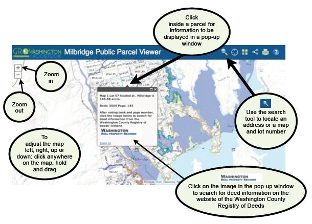
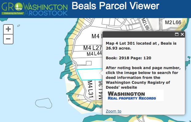
You can SEARCH for your parcel by address or lot number and click a link to obtain deed information from the Washington County Real Property Records office in Machias.
DOWNLOAD PARCEL MAP VIEWER INSTRUCTION GUIDE HERE.
REMEMBER - the data is only as complete as it was provided by your town. Some towns provided far more information than others and will find the maps more useful accordingly.
Data can be added and the University of Maine at Machias GIS Service Center is making a long term commitment to keeping it up to date and as useful to communities as possible. If you find errors, have updates, or want more information, contact Tora Johnson.
The Public Parcel Maps and Planner Maps are the products of several years of work by the students, graduates, and employees (and employed graduates!) of the UMM GIS Service Center. Under the supervision of Director Tora Johnson, they contributed countless hours of time in the creation of these maps:
digitizing (sometimes from pencil on a paper base map from the 1870s)
- interpreting deeds
- contacting municipal officials from every town in Washington County
- finding, connecting, integrating and presenting data
- pushing the limits of the software
- demanding new tools of the software engineers
- beta testing and refining the software
- modeling legislation into shoreland zoning districts
- preparing instruction guides
Click on links below for Public Parcel Maps for Washington County towns to view parcel maps.
 Connect to the Washington County Real Property Records office - write down the Book and Page Number, then click to obtain the recorded deed for the parcel.
Help is available on the map itself and/or download the Public Parcel Map Instruction Guide (PDF)
or download Instruction Videos here.
Public Parcel Maps
Please take our 5-minute User Feedback Survey — help us improve the online mapping tools and training resources — Thanks!
- Addison - Public Parcel Map
- Alexander - Public Parcel Map
- Baileyville - Public Parcel Map
- Beals - Public Parcel Map
- Beddington - Public Parcel Map
- Calais - Public Parcel Map
- Charlotte - Public Parcel Map
- Cherryfield - Public Parcel Map
- Columbia - Public Parcel Map
- Columbia Falls - Public Parcel Map
- Cooper - Public Parcel Map
- Crawford - Public Parcel Map
- Cutler - Public Parcel Map
- Danforth - Public Parcel Map
- Deblois - Public Parcel Map
- Dennysville - Public Parcel Map
- East Machias - Public Parcel Map
- Eastport - Public Parcel Map
- Harrington - Public Parcel Map
- Jonesboro - Public Parcel Map
- Jonesport - Public Parcel Map
- Lubec - Public Parcel Map to Top
- Machias - Public Parcel Map
- Machiasport - Public Parcel Map
- Marshfield - Public Parcel Map
- Meddybemps - Public Parcel Map
- Milbridge - Public Parcel Map
- Northfield - Public Parcel Map
- Pembroke - Public Parcel Map
- Perry - Public Parcel Map
- Princeton - Public Parcel Map
- Robbinston - Public Parcel Map
- Roque Bluffs - Public Parcel Map
- Steuben - Public Parcel Map
- Talmadge - Public Parcel Map
- Topsfield - Public Parcel Map
- Vanceboro - Public Parcel Map
- Waite - Public Parcel Map
- Wesley - Public Parcel Map
- Whiting - Public Parcel Map
- Whitneyville - Public Parcel Map to Top

Share this content: